Philippines make over
:: quirino walkable district: opportunity sites
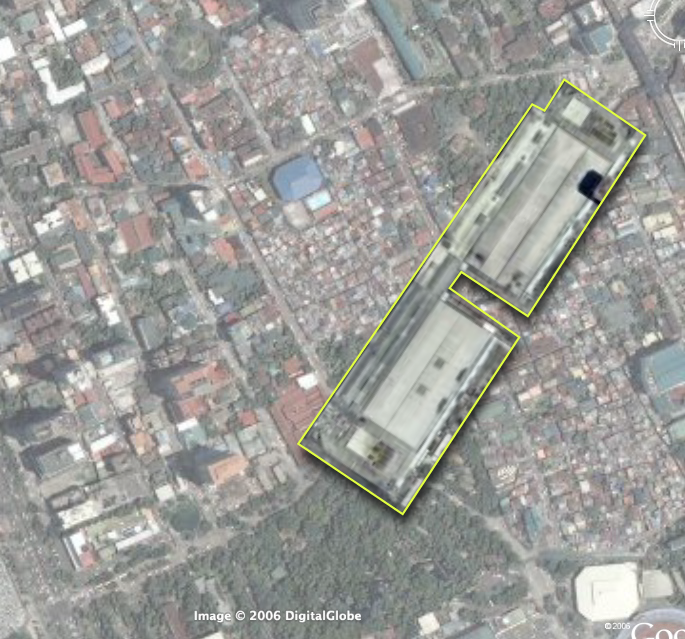
(Cross posted on Another Hundred Years Hence.)Next on our urban sketch project, let's look at the opportunities for redevelopment in our proposed walkable district. (You can catch up with parts 1 and 2 of this series.)Focusing on the middle path -right down Quirino Avenue -we find more than 8.5 hectares right along the corridor that would be ripe for redevelopment. (Click on the picture for a larger image outlining the sites, check out the opportunity sites on Google Maps or download kml file (2.1kb).)Also, just to give you context about the opportunity available, here are scale comparisons of the site vs. Glorietta and vs. Megamall (thumbnails after the jump).The eleven opportunity sites are a combination of national and local government owned land and underutilized, privately owned lots. The redevelopment of the area then requires government incentives and public-private partnerships.The largest chunks, thankfully, are in government control. The properties are also located at very strategic portions of the path. They include the two Bureau of Plant Industry (BPI) lots, the Leveriza (Manila) Children's Park and a segment of the Manila Zoo.The two BPI lots make up about 3.3 hectares. If zoned for an FAR* of 2.5, the lots could deliver as much 890,000 sq.ft. (82,500+ sqm.) of development to the market. The lots are ideal for transit oriented development (mixed-use, with retail on the ground floor, office spaces and three to five residential towers) - taking strategic advantage of the Quirino LRT station -and catering to Makati workers, with the CBD just 7 stops (4 on LRT-1 and 3 on the MRT) and one transfer away. The residential component (condo and apartments) could also service the housing demand from students from DLSU and the other schools nearby.The national government (BPI is under the Department of Agriculture) would do better to relocate the Bureau to where it could better serve its agricultural clientele -or where it could be closer to other agri research centers (like Los Banos). They could also require exactions from the sale, say by requiring that a percentage of the residential units be set aside for subsidized housing for public school teachers.Meanwhile, the Manila Zoo could raise much needed funds by leasing off part of its property along Quirino. They could give up about 100 feet deep of the zoo's layout and bring about 12,000 square meters to market. (This project might already by under contemplation by the Friends of Manila Zoo Foundation, as I found a 1997 EMB circular (pdf) listing an ECC for a Manila Zoo Redevelopment Project under a company called "Zoo Village Redevelopment Corp.") This would allow the zoo to raise funds and they can also elevate the zoo's civic presence by requiring the leasee to build a structural entrance to the zoo. (Which would be way better than just the current metal sign.) The lease can also provide structured parking for the zoo.The zoo's location at the bend of Quirino makes it ripe for a more visible structural entrance that would serve as a terminating vista, calling strollers from the corner of Qurino and Taft to walk down to the bend and the zoo entrance. The new entrance would neatly bisect our proposed pedestrian path -and serve as a waypoint from the LRT station to the bay and the baywalk.Manila City could also raise funds and improve the services of the children's park by leasing off the property but requiring the lessee to set off the majority of the lot for a much improved children's park. The lessee can also be required to maintain the park freeing the city of the maintenance costs.Likewise, Ospital ng Maynila could raise operational funds by leasing off its Quirino edge and its parking lot fronting the bay. They could require the lessee to provide structured parking for the hospital.The rest of the opportunity sites are probably privately held properties and include a large empty lot (since the Google Earth image is at least a year old, the propery may not be vacant anymore), a motel, a possible defunct water storage facility and two large underutilized properties that currently house a gas station and some nominal office spaces.The city government could provide incentives for redevelopment of these particular properties.Here's a rundown of the sites.
Site
est. area (m2)
1. Bureau of Plant Industry
20,000
2. Bureau of Plant Industry 2
13,000
3. Empty lot
2,800
4. Manila Children's Park
12,500
5. Manila Zoo Edge
12,000
6. Motel
4,600
7. Ospital ng Maynila Edge
2,750
8. Ospital ng Maynila Parking Lot
3,800
9. Underutilized property 1
6,500
10. Underutilized property 2
4,800
11. Water storage facility (?)
2,100Images on the left: the area compared to Glorietta (top) and Megamall (bottom). Click for larger versions.What's missing:If this were a full urban planning study, we would do well if we had:
the zoning map for the area
a property list along with a cadastral or tax assesment map
current pictures of the existing buildings on the sitesNext up: Streetscape and a massing and volume study.
*Floor Area Ratio (also called Floor Space Index) = (Total covered area on all floors of all buildings on a certain plot) / (Area of the plot)
:: quirino walkable district: nodes and paths
(This entry cross posted at Another Hundred Years Hence.)Getting back to our urban planning sketch (part 1 here), one way to think about walkable districts is to think of nodes and paths. (This is pretty much a Kevin Lynch approach.)Nodes are centers of activity - paths are...well, paths that connect the nodes. Nodes also tend to define the area around the node -turning the area into a "district" of sorts. Nodes can center around a single significant building or can be formed by a cluster of activities.Paths of the other hand, have the power to define the edges of districts.I've picked out the key nodes in our project area and the paths that connect them. It's important to think of nodes when planning walkable districts as the nodes serve as destinations and define the types of activities in the walkable district. The nodes also define the character of the paths - who uses the paths and what time of the day the path will be most used.So our project area (which I am defining as the area loosely bound by the two transport nodes of the Quirino and the Vito Cruz LRT stations - and then the area west from the stations to the Bay), has several clusters of nodes -with different activities. (Click on the picture for a larger image or download the high res version here (png 3.3Mb) or download the kmz (164kb) file -with image overlay -here.)The nodes and their surrounding activities include:
The north cluster with:
The Malate Church -with its public park foreground -and the park bordered by all day restaurantsRemedios Circle -which is actually a barely used public park -also surrounded by restaurants -most of whom provide active nightlife to the area (UPDATE: Citizen of the World has great pics of the new Remedios Circle, and he links to Bong Austero's musings on the redesigned park), andthe San Andres Public Market
A middle cluster defined by:
The Manila Zoo, and The Leveriza Children's Park (formerly Paraiso ng Batang Maynila)
A south cluster with:
.jpg)
The Rizal Memorial Sports Center - which also serves as a concert venue apart from sports centerHarrison Plaza (a shopping center)
Several other important destinations at the very edge of the district:
The Metropolitan MuseumThe Manila Yatch ClubThe Cultural Center of the Philippines Complex (including the FAT and the PICC)Another major destination is, of course, the Bay itself.Three possible pedestrian corridors (green lines) serve these clusters.
A northern path from Quirino Station to Malate Church via San Andres Road (with a branch that turns north to Remedios Circle)
A middle path from Quirino Station to the Bay right past the Zoo and the Children's Park (along Quirino Avenue)
A southern path from the Vito Cruz Station -right up Vito Cruz St. to the CCP complex.There are two other signficant pedestrian corridors:
M. Adriatico St. between Vito Cruz and Quirino (connecting Rizal Memorial and Harrison Plaza to the Zoo and the Park)
Roxas Boulevard (does Baywalk stretch all the way to here?) at the western edge of the districtI've color-coded the nodes -green for parks, blue for cultural (including sports), and red for commercial.There are other ways to classify the nodes that will help us think about the activity patterns. The zoo and the park are daytime activities -while CCP, FAT and the Sport Center serve daytime activities with surge activities (major concerts and sports events) in the evening and on weekends.)Ideally we should also have the numbers on how many people go to these nodes (both during regular hours and during surge events).The activities, the hours, the number of people will tell us what other facilities we need in the area if we are to serve a pedestrian audience.It's also important to consider major traffic thoroughfares (in gray) bisecting the study area, which in our case (and by order of traffic volume) are:
Roxas Boulevard
Taft Avenue
M. Adriatico
F.B. HarrisonAlthough Quirino (east-west) does carry some load, significant traffic flows mainly along the these north-south arterials.(Next up, Opportunity Sites.)
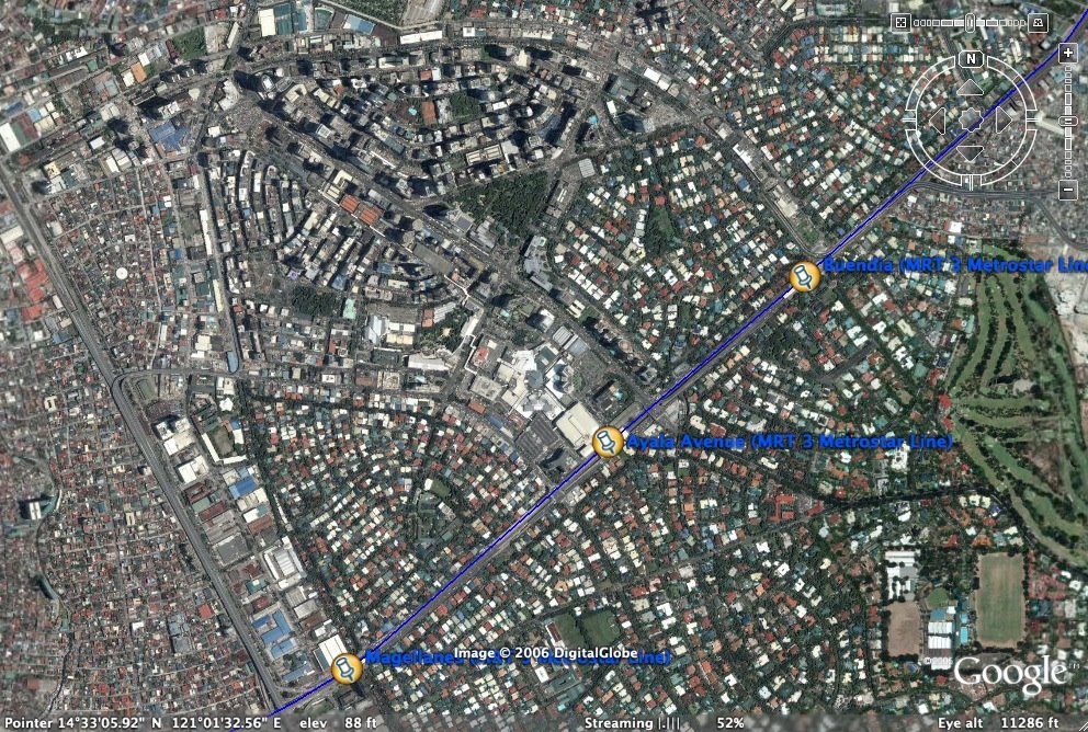
:: creating the quirino walkable district:an urban planning sketch
(cross posted from Another Hundred Years Hence)Roby's original intent with the Philippines Makeover blog was to inspire people to use Google Earth and SketchUp to reimagine our cities. I am finally indulging him (and myself) with a sketch study on creating a walkable district using Quirino LRT station as the epicenter -with Quirino Avenue as the axis and the southern Malate district as the study area. I'd like to explore how we can improve this part of the city by making it more walkable -and hopefully, more livable.Click on the image to the right to see a larger view of the study area. You can also see the area and the markers on Google Maps. If you prefer, you can download the kmz file for viewing on Google Earth.Why the Quirino Station? I don't know. It seemed a good a choice as any but what appealed to me was it's proximity to several urban amenities (the zoo, the bay, the sports center, remedios circle, leveriza children's park, etc.). The stretch of Quirino between Taft Avenue and Roxas Boulevard also presents some very interesting opportunity sites.I am doing this urban planning sketch...
as a thought experiment, to see what possibilities there are
as a model/instigation to hopefully jumpstart other flights of imagination
as a showcase of physical urban planning -to show what comes into play and into consideration when you plan an area (i.e. -the physical designs, the policy approaches and the community consensus building)A blogpost is a limited medium when it comes to illustration so I will try to create a pdf version of each post complete with maps and diagrams.So we start with the walking shed. A normal, healthy person can comfortably cover 1/4 of a mile during a 5 minute walk and 1/2 a mile during 10 minute walk. (The number is awkward when translated into kilometers -but if you want the figures: 5 minutes = 0.402336 km or 400+ meters; 10 minutes = 804672 km or 800+ meters.) That radius has been the basis for the design of neighborhoods since Clarence Stein and Henry Wright proposed the plan for Radburn, New Jersey. (If the Radburn plan looks familiar to you, whip out your Google Earth and navigate to Philamlife Subdivision. Philam as well as most of the QC Projects were patterned after the Radburn/Garden Cities template.)The following landmarks are within a 10 minute walk radius of the Quirino LRT Station:
The bars in malate
The Remedios Circle
The San Andres Market
Malate Church
The Manila Zoo
The Leveriza Children's Park
Ospital ng Maynila
Harrison Plaza
The Rizal Sports Complex
DLSU, Benilde, St. Scho and PCUand just a little further off:
The MET
Bangko Sentral
The Manila Yacht Club
The Army-Navy Club
UP Manila
PGH
NBI
The Supreme Court
Robinson's MalateSo you see, the walkshed has a lot of promise.I'd like to fill up this map with as much data as I can and gather as many landmarks as I can place within the walkshed, so if you have the time and GoogleEarth skills, churn out markers on places / landmarks (restaurants, shops, offices, etc.) within the walkshed and send us the kmz files.Digital copies of barangay maps of this district would also be very helpful.Next up: opportunity sites within the walkshed.
:: I can see clearly now
As typhoon Milenyo did its bit and erased a lot of those ugly billboards along EDSA and (hopefully) finally opened our officials' eyes to the hazards and eyesores that the outdoor ads represent, Google Earth was quietly clearing the air over Metro Manila as well.GE's evidently updated some images for the Philippines, so Makati for one -- the Central Business District, to be precise -- is now unobscured by low-lying clouds and can finally be seen in all its high-res glory.
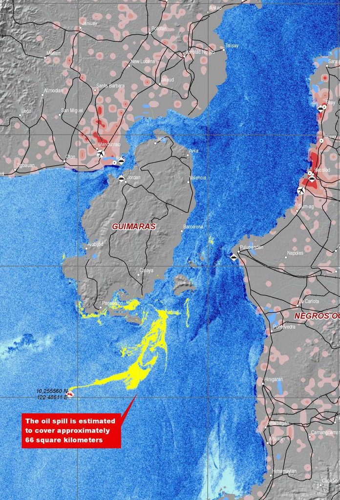
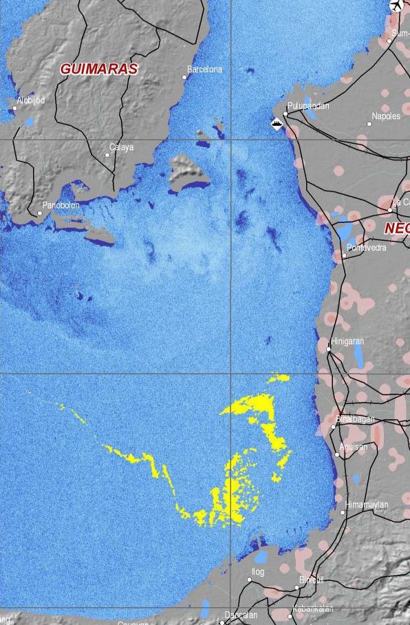
:: Help Guimaras
It shouldn't have to take something this tragic to have us posting again, of course, but as Filipinos not currently in town, we've been especially anxious for news and pictures to show how extensive the oil spill in Guimaras exactly is. We totally relate with this plea for help and more information posted by Cpee on the Google Earth Community billboard.Project Sunrise, a website put up by the Guimaras government tries hard and does well to keep us up to date on the news, and is an important initiative to drum up/coordinate help for the province.Meantime, we've taken two satellite maps (one taken on August 24, the other on August 27) offered by UNOSAT and converted those into image overlays that you can open on Google Earth. Side by side with Cpee's markers, they give you a good idea of the extent of this calamity, and how it's not just Guimaras that we should be worried about.Greenpeace has posted many pictures (such as the one above) to show the impact this oilspill is so far having on the people of Guimaras. Meantime, the Google Earth markers and image overlays are all available in one KMZ file at Google Earth Philippines.)
:: Stay tuned for Baguio
Was about to post this on Google Earth Philippines, but PBWiki's down. If you've been having problems accessing the wiki for all the Google Earth markers we've compiled, PBWiki says we'll just have to wait for "a few hours".Oh well. We'll post some KMZs on Baguio as soon as PBWiki's back online, and this one's going to be worth the wait. Thanks to Caesar Angeles, who clearly loves his hometown. He calls himself a beginner on Google Earth and KMZs. But aren't we all?
Maraming Salamat Po
No comments:
Post a Comment